8/25/2008

The Key...?

Almost a week ago I showed you the island depicted in the photos in Captain Gault's stateroom: Ni'ihau.
Yesterday I realized of something in common between this island and our Island... or, at least, between Ni'ihau and one of the maps of the Island.
I noticed that one zone of Ni'ihau is very similar to one particular landmark in Ben's Radio Tower Map:
This is Ni'ihau, one of the oldest island in the state of Hawaii.
In the most southern part of this island there's a "strange rocky formation", strangely shaped.
Let's take a closer look.
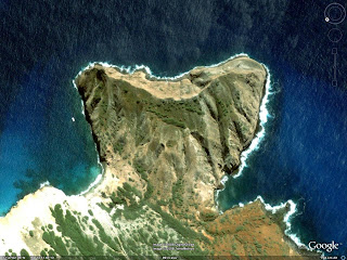


This is the part I was talking about. It appears its name is Kawaihoa Pt.
For those who didn't realize it yet, let's take a look to Ben's map.


The upper right part of the map is very similar to Kawaihoa Pt. in Ni'ihau. And probably they have also the same geological formation.


After a couple hours of research I found that Kawaihoa Pt. is a so-called "tuff cone". On various websites it is explained it is the product of a phreatomagmatic eruption, caused by the interactions between magma and water; though, maybe because my knowledge in volcanology is not that great, I didn't understand if a tuff cone is what remains of the crater or is just the real product of the eruption... If someone can clarify this aspect, it would be great.
Anyway, if all of this is right, than we can conclude that the beach camp is really near a volcanic crater (or what remains of it). Looking at Rousseau's map, there seems to be only one volcano on the Island (not sure about this, though). If this is really the case, then we can firmly conclude that the beach camp is somewhere east of the volcano (this is deduced by looking at Ben's map). So, hopefully, my map of the various location of the Island is right for the most part... At least, in a geological sense of it ;) .

8/20/2008

3D Model

These images are from a 3D map of the Island I created, and I've been working on it since May.
I managed to import it in Google Earth and that's the reason there's written the Google logo in every image (and the NASA writing is about the photo of the ocean, of course).
Unfortunately, I cannot use personalized textures on this kind of model, so I had to create it monochromatic. And it's not very accurate too... But it's a start, I guess.
Anyway, I hope it can help someone!

8/19/2008

Various Maps

In some episodes of Season 4 we saw a couple of maps we couldn't recognize very well.

For example, in episode 407 (Ji Yeon) we can see some charts on the wall of Captain Gault's stateroom.

We can see some drawn maps and some satellite/aerial photos.
One of the maps shows a couple of bigger islands along with some smaller islands. These islands are the Fiji, the place where the Kahana took off.

The satellite/aerial photo could be, theorically, images of the Islands, but, in reality, they are photo of an existing island in the Pacific. After some time of research, I found that the island used for the photos is Niihau, one of the islands in the Hawaii archipelago.


So, if someone thought these maps could be used to locate the (previous) position of the Island... They cannot.


Another map that caught my attention was, in Cabin Fever (411), the map in the pack Lapidus threw from the helicopter. I don't have a very good screenshot of that map; here's the best I have.

The visible letters are "...I_IBA...".
The state the map refers to is Kiribati.

So we can conclude that the map was a map of the islands in the Pacific Ocean... So the possibility that the Island was in the Pacific Ocean is very very high... This against those who still thought the Island was somewhere else...
Ok, let's end here this useless post... I hope that soon we can know where the Island is NOW...

8/17/2008

Coincidence?

Ok, maybe I'm looking too much into it, but I think another map is coherent with the Radio Tower/Cabin Map.
Probably it's just a coincidence but some of the coastlines and (maybe) some mountains in the Map Faraday used to go to the Tempest Station are the same as the previous map!


But then there's a problem... I think that Rousseau's maps is going to be the least accurate map of all the maps we have... Or at least, I can't find a solution to get together these maps considering both the coastlines and the mountains.
Hope someone can help!