9/17/2008

Le cratère

I don't know if what you're about to read is correct, I have doubts too, but it seems too much to be a coincidence. I don't know why I'm writing this either; probably I just want to be told if it's right or wrong, if all of this is just in my mind... I need to know.

I was trying to get something from one of Rousseau's maps, aka the "other" map, the one with the side-view and the crater on it.
I have a theory, that combining various parts of Oahu you can create the Island as seen on Rousseau's Maps. If this theory is true, then the side-view map should represent a part of Oahu. Because the word "cratère" appears on the map, we can assume that the map represents a volcano.
Oahu has a lot of volcanoes, however I tried with just a couple of them, because on my second attempt I had positive results. These are the map and the volcano I'm talking about. The volcano is Koko Crater in the southeastern part of Oahu.

As you can see, there isn't a perfect match, but they are *very* similar.

If the outline of the crater doesn't match perfectly, it is, however, very similar to the one of the crater on the map. Moreover, the visible side of the volcano in the image, is the south one, meaning that we're facing north. In Rousseau's map, this situation is shown too.
Then I found a topographical map of the volcano and created a 3D model. After a couple of days of work, this is the model I obtained. It represent the volcano from a height of 200 ft to 1200 ft (61m to 366m) and is created with an accuracy of 40 ft (at least, I guess).

When I looked at the model from above, it appeared as in this image.

Then I compared this image with an image of the crater from the "main" Rousseau's map. I don't know if the whole Koko Crater matches the crater on the map (it doesn't seem, anyway), but I think that at least the edge (red) of the crater matches almost perfectly. And the most strange (or maybe, amazing) thing is that the orientation of the image of the 3D model has North as up, as in the actual "main" map. So it didn't need rotating.

A couple of problem would remain: what about the scale, giving the crater a height of 3000m? I think it doesn't states the crater height; as you can see, on the opposite side of the map, there's a "latitude" scale, and the latitude cannot be measured in a line perpendicular to the Earth. Sometimes, however, lines are shown as vertical because of perspective, because measures on lines converging at a vanishing point would be as shorter as approaching to the point. So probably 3000m is the lenght of the crater in a North-South direction (the height scale, the latitude scale and the North Arrow are all vertical lines). Another problem would be: why, then, there's nothing behind the crater on the map? The only possible answer that comes to my mind is: probably Rousseau just wanted to draw the crater only and not the rest of the Island...

The conclusion is that it would seem that the side-view map represents the crater on the south as seen from a 000 direction. However, I'm still a little confused... I need clarifications... Or some help... Because something that yesterday seemed being senseless, today it has sense... And it's too much strange... And confusing...

9/15/2008

Swan Station Road Map 3D

Because it was asked, here it is: I just finished the Swan Station Road Map 3D model. I took the map for this model from episode 310 (Tricia Tanaka is Dead); however, the map wasn't completely visible and it was ruined, so I have reasons to believe this model is not as accurate as the previous one.
As you can see, there's the road too (my hand isn't that accurate as I am, though...). I didn't drew the station, but it would be right in the valley.

9/13/2008

3D Cable Map

Today I tried to make a new 3D model. This time I used the Cable Map from Enter 77 (311) and Par Avion (312) to make the model.
I used the elevation lines on the map to create this 3D model, so it should be quite accurate. The black line is just the Sonic Fence around the Barracks. Probably it's the first time we have an "original piece of the Island" in 3D... What do you think?

8/25/2008

The Key...?

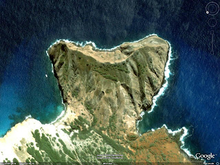
Almost a week ago I showed you the island depicted in the photos in Captain Gault's stateroom: Ni'ihau.
Yesterday I realized of something in common between this island and our Island... or, at least, between Ni'ihau and one of the maps of the Island.
I noticed that one zone of Ni'ihau is very similar to one particular landmark in Ben's Radio Tower Map:
This is Ni'ihau, one of the oldest island in the state of Hawaii.
In the most southern part of this island there's a "strange rocky formation", strangely shaped.
Let's take a closer look.


This is the part I was talking about. It appears its name is Kawaihoa Pt.
For those who didn't realize it yet, let's take a look to Ben's map.


The upper right part of the map is very similar to Kawaihoa Pt. in Ni'ihau. And probably they have also the same geological formation.


After a couple hours of research I found that Kawaihoa Pt. is a so-called "tuff cone". On various websites it is explained it is the product of a phreatomagmatic eruption, caused by the interactions between magma and water; though, maybe because my knowledge in volcanology is not that great, I didn't understand if a tuff cone is what remains of the crater or is just the real product of the eruption... If someone can clarify this aspect, it would be great.
Anyway, if all of this is right, than we can conclude that the beach camp is really near a volcanic crater (or what remains of it). Looking at Rousseau's map, there seems to be only one volcano on the Island (not sure about this, though). If this is really the case, then we can firmly conclude that the beach camp is somewhere east of the volcano (this is deduced by looking at Ben's map). So, hopefully, my map of the various location of the Island is right for the most part... At least, in a geological sense of it ;) .

8/20/2008

3D Model

These images are from a 3D map of the Island I created, and I've been working on it since May.
I managed to import it in Google Earth and that's the reason there's written the Google logo in every image (and the NASA writing is about the photo of the ocean, of course).
Unfortunately, I cannot use personalized textures on this kind of model, so I had to create it monochromatic. And it's not very accurate too... But it's a start, I guess.
Anyway, I hope it can help someone!

8/19/2008

Various Maps

In some episodes of Season 4 we saw a couple of maps we couldn't recognize very well.

For example, in episode 407 (Ji Yeon) we can see some charts on the wall of Captain Gault's stateroom.

We can see some drawn maps and some satellite/aerial photos.
One of the maps shows a couple of bigger islands along with some smaller islands. These islands are the Fiji, the place where the Kahana took off.

The satellite/aerial photo could be, theorically, images of the Islands, but, in reality, they are photo of an existing island in the Pacific. After some time of research, I found that the island used for the photos is Niihau, one of the islands in the Hawaii archipelago.


So, if someone thought these maps could be used to locate the (previous) position of the Island... They cannot.


Another map that caught my attention was, in Cabin Fever (411), the map in the pack Lapidus threw from the helicopter. I don't have a very good screenshot of that map; here's the best I have.

The visible letters are "...I_IBA...".
The state the map refers to is Kiribati.

So we can conclude that the map was a map of the islands in the Pacific Ocean... So the possibility that the Island was in the Pacific Ocean is very very high... This against those who still thought the Island was somewhere else...
Ok, let's end here this useless post... I hope that soon we can know where the Island is NOW...

8/17/2008

Coincidence?

Ok, maybe I'm looking too much into it, but I think another map is coherent with the Radio Tower/Cabin Map.
Probably it's just a coincidence but some of the coastlines and (maybe) some mountains in the Map Faraday used to go to the Tempest Station are the same as the previous map!


But then there's a problem... I think that Rousseau's maps is going to be the least accurate map of all the maps we have... Or at least, I can't find a solution to get together these maps considering both the coastlines and the mountains.
Hope someone can help!

7/31/2008

Incongruence

If we compare Danielle's main map of the Island and this map, we can conclude that there's something strange about these maps: they don't seem to be maps of the same Island! Or: maybe they are maps of the same Island, but one of them, or maybe both, are not accurate. We have to make a choice: consider Danielle's map, drawn by a crazy woman, stuck on an Island for sixteen years, during which she could have acquired “geographical” experience of the Island, as the “real” map OR we have to consider that maybe her maps are not very accurate and that maybe she could have drawn a map that wasn't representing exactly the Island itself.
In the first case, we wouldn't have enough information to create a map of everything on the Island (Dharma Stations, camps, etc); in the latter we could do that, but we'd have only a partial view of the Island, because we wouldn't be able to adapt exactly Danielle's map to the “Dharma maps”.
What do you think?